Map feels stuck or unresponsive
After panning far away or zooming to an extreme view, tiles may stop updating or the map may feel sluggish. Use the toolbar scope button on the WX Radar tab to reset the view.
- Open WX Radar.
- Tap the scope button (left of Refresh) — recenters on GPS or your marina preset, clears the saved pan/zoom, and reloads radar and chart tiles.
- If you use Lock chart overlays, tap Refresh once after reset when viewing a new harbor scale.
The app also clamps extreme zoom levels so a saved viewport cannot pin the map at a world-scale view that disables useful overlays.
Coverage — where this app is designed to work
Outside those areas the map may show limited or no radar returns, and navigation layers fall back to Global free depth shading and community seamarks — useful for reference, but not for primary navigation. Always use your helm chartplotter (for example Raymarine Axiom charts) for underway decisions.
Settings tab — what lives there
Open More → Settings (gear icon in the icon bar) for app-wide preferences that persist across sessions. Settings requires an active subscription.
| Section | What you configure |
|---|---|
| Vessel | Read-only summary of owner and primary vessel name. Full editing — owner contact, registration, insurance, dinghy, trailer, photos, and thru-hulls — is under Skipper → Vessel. Vessel name and MMSI propagate to Logbook → AIS. See Owner & Vessel Registration guide. |
| Radar & Map | Default radar center (My GPS or coastal / Great Lakes region), default Weather vs USN map, and entry to Map & Display Settings. |
| Logbook — Position Tracking | Automatic GPS position logging (lat/lon only) interval while the app is open. Speed and course are not recorded. |
| WX Radar | Manual radar image refresh, copy-current-GPS for sharing coordinates, and the on-map Marine Conditions panel (waves control). |
Switch map mode on the radar toolbar: Weather (cloud) or USN (sailboat). Tap Refresh to reload tiles, or Reset (scope icon) to recenter and clear a stuck view. Tap the waves control to open the Marine Conditions panel (local wind, seas, tides, moon, forecast); tap again or the dimmed area to dismiss.
Marine Conditions — local current conditions
Marine Conditions is the named modal panel for a quick on-water snapshot. It is available from WX Radar (waves toolbar control) and when creating a Captain’s Log entry.
- Open WX Radar.
- Tap the waves control (top of the map toolbar).
- Read air, sky, wind, seas/swell, moon, NOAA tide station, high/low tides, tide curve, and short forecast.
- Tap waves again or the dimmed scrim to close the panel.
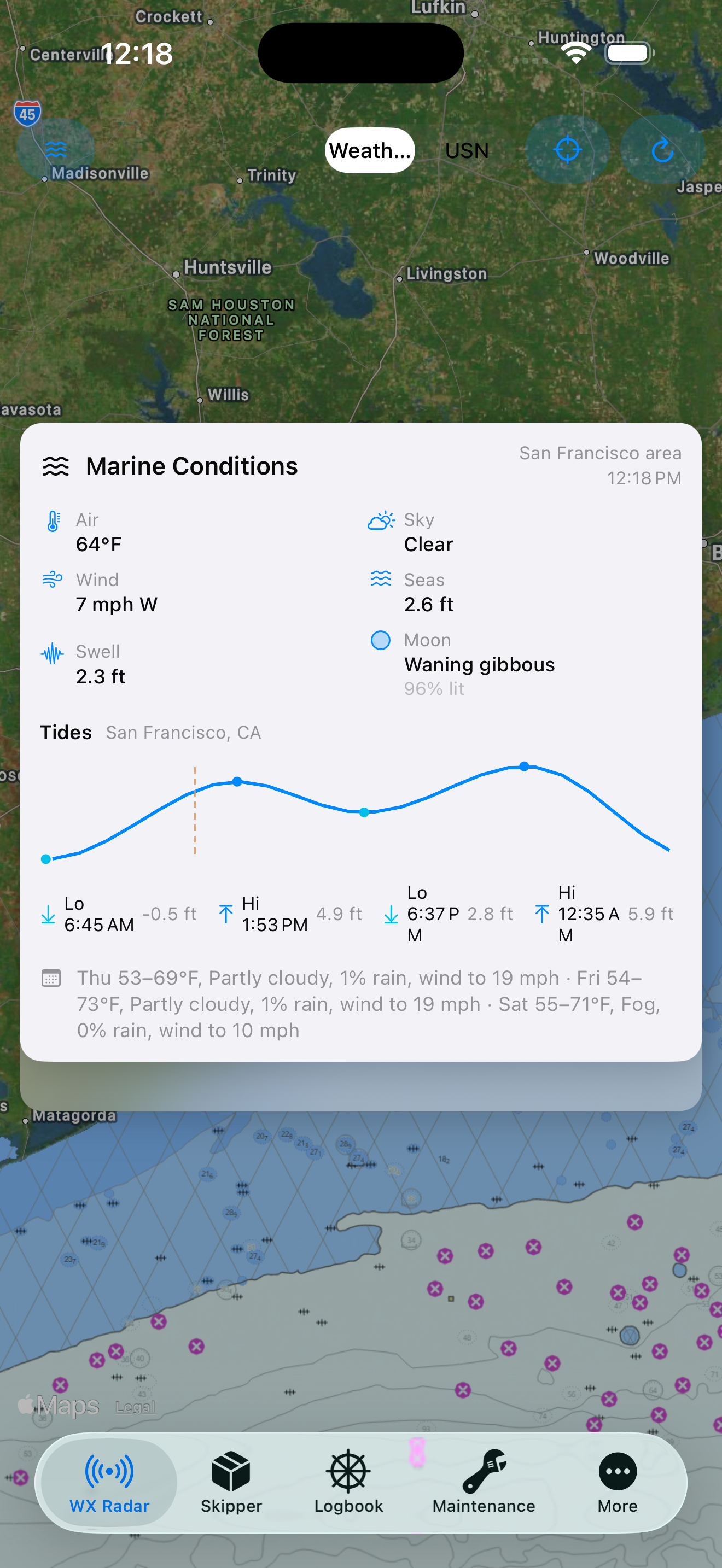
Training: Marine Conditions on WX Radar
Stable weather radar image
For a single, non-moving radar frame — easier to read a squall line or share a screenshot — turn off animation on the Weather map.
Freeze the radar loop
- Open Settings → Radar & Map → Map & Display Settings.
- Under Weather Map, turn off Animate weather radar loop.
- On the Weather map, only the latest radar frame shows — no cycling through past images. The USN map always uses a static radar underlay.
| Goal | Settings |
|---|---|
| Still radar, no animation | Animate weather radar loop → Off (Weather map) |
| Radar + depth + buoys | Radar toolbar → USN |
Chart regions — U.S., tropics, and global
| Region | Best for | Layers (USN map) |
|---|---|---|
| Auto (by map center) | Cruising U.S. → Bahamas → Caribbean | NOAA in U.S. waters; tropical stack in Bahamas/Cuba/Caribbean; global free elsewhere |
| U.S. NOAA | Galveston Bay, Gulf Coast, U.S. coastal waters | Depth soundings, buoys & lights from NOAA ENC aids |
| Tropics | Bahamas, Cuba, Caribbean, tropical Atlantic passages | GEBCO + EMODnet bathymetry, OpenSeaMap seamarks |
| Global free | Pacific, Indian Ocean, and other non-tropical areas | GEBCO bathymetry shading, OpenSeaMap seamarks |
The USN map picks the region automatically from your map center. The toolbar badge shows Tropics when tropical layers are active.
Quick reference — where to change what
| Setting | Settings tab | On radar map |
|---|---|---|
| Map emphasis (Weather / Navigation) | Radar & Map picker | Map → Emphasis |
| Default radar center | Radar & Map picker (GPS + A–Z regions) | Map → Center |
| Animate radar loop | Map & Display Settings | Map → Animate loop |
| Lock chart overlays | Map & Display Settings | Map → Layers |
| Refresh chart / radar view | WX Radar → Refresh Radar Images | Map → Refresh |
| Owner & contact | Owner & Contact | — |
| Primary vessel name & MMSI | Skipper → Vessel | Logbook → AIS (synced) |
| GPS position logging | Position Tracking section | — |
Common scenarios
Pre-departure squall check (marina)
- Map emphasis → Weather.
- Animate radar loop → On to see storm motion (~30 minutes of NEXRAD history).
- Center on your default radar region (e.g. Galveston Bay) or My GPS Location. The default range ring is 32 nautical miles.
- For chart context, switch to USN — NOAA layers come on and radar animation freezes (by design).
Marketing overview: Inventory & Weather NAV maps.
Inbound channel — radar + depth, minimal motion
- Map emphasis → Navigation.
- Animate radar loop → Off for a steady picture.
- Lock chart overlays → On; tap Refresh after setting zoom.
- Charts → U.S. NOAA (or Auto in U.S. waters).
Away from the boat — center on phone GPS
- Settings → Radar map center → My GPS Location.
- Allow location permission when prompted.
- Open WX Radar so the map centers on your position.
About tab
Open the About tab for version info, publisher details, and links to this documentation hub.
| Item | What you get |
|---|---|
| App icon | Tap the icon for a large detail preview sheet. |
| Guides | Shortcuts to workflows, settings, vessel registration, and features. |
| Support | Link to the customer forum for questions and feedback. |
Version 1.0 — see the release notes for what’s included.